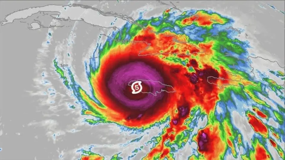
A dramatic satellite image showing an enormous hurricane with a “Category 5” label has spread rapidly across social media alongside claims that Hurricane Melissa struck Jamaica on October 28, 2025, with 185 mph sustained winds and a minimum central pressure of 892 mb. According to the viral posts, the storm tied some of the most powerful Atlantic hurricanes ever recorded and produced catastrophic conditions across the island.
The striking imagery and alarming statistics have captured widespread attention, prompting many people to wonder whether one of the strongest hurricanes in Atlantic history truly made landfall in Jamaica.
A Storm Described as Historic
The posts describe Hurricane Melissa as an exceptionally powerful tropical cyclone that rapidly intensified before making landfall near New Hope on Jamaica’s southwest coast.
According to the circulating claims, the hurricane reached:
- Category 5 strength
- Sustained winds of 185 mph (298 km/h)
- Minimum central pressure of 892 millibars
- A direct strike on Jamaica
If accurate, these measurements would place Melissa among the strongest Atlantic hurricanes ever observed.
Supporters of the claim compare the storm to legendary hurricanes including Hurricane Dorian (2019) and the devastating Labor Day Hurricane of 1935, both remembered for extraordinary intensity.
The accompanying satellite image appears to show a perfectly formed eye surrounded by deep convection, giving the impression of an extremely dangerous cyclone approaching Jamaica.
Why Category 5 Hurricanes Matter
Category 5 represents the highest classification on the Saffir-Simpson Hurricane Wind Scale.
Storms reaching this level produce sustained winds of at least 157 mph (252 km/h) and have the potential to cause catastrophic destruction.
These hurricanes can generate:
- Complete roof failures
- Collapsing walls
- Massive storm surge
- Widespread flooding
- Long-term power outages
- Severe damage to roads and infrastructure
Because true Category 5 landfalls are relatively rare, reports of one striking a populated island naturally generate enormous public interest.
Rapid Intensification Has Become a Growing Concern
One reason stories like this spread so quickly is that meteorologists have increasingly observed storms strengthening much faster than in previous decades.
Rapid intensification occurs when a tropical cyclone gains at least 35 mph in sustained winds within 24 hours.
Warm ocean temperatures, abundant moisture, and favorable atmospheric conditions can allow storms to strengthen dramatically shortly before reaching land.
Recent Atlantic hurricanes have demonstrated how quickly conditions can change, leaving communities with less time to prepare.
This growing concern has made emergency management agencies place greater emphasis on early preparedness, evacuation planning, and continuous monitoring throughout hurricane season.
Understanding Historic Hurricane Records
Claims that a hurricane reached 185 mph sustained winds and a minimum central pressure of 892 millibars are significant because those figures would place the storm among the most intense Atlantic hurricanes ever documented.
Meteorologists measure hurricane intensity using several key indicators:
- Maximum sustained wind speed, averaged over one minute.
- Central pressure, with lower pressure generally indicating a stronger storm.
- Storm surge potential, which depends on wind, pressure, coastal geography, and the storm’s size.
- Rainfall totals, which often produce flooding far inland even after winds weaken.
While powerful winds receive the most attention, water is responsible for many hurricane-related fatalities. Storm surge and freshwater flooding often create the greatest danger for coastal communities.
Preparing Before a Major Hurricane
Whether a storm reaches Category 3, 4, or 5, emergency officials consistently recommend preparing well before landfall.
Important hurricane preparedness steps include:
- Monitoring forecasts from official weather agencies.
- Knowing local evacuation routes.
- Preparing an emergency kit with food, water, medications, flashlights, batteries, and important documents.
- Charging phones and backup power banks.
- Securing outdoor furniture and loose objects.
- Following evacuation orders immediately if issued.
Preparation becomes especially important because forecasts can change rapidly as storms approach land.
Why Viral Weather Posts Deserve Careful Verification
During hurricane season, dramatic satellite images and alarming captions often spread widely across social media. Some posts accurately summarize developing storms, while others mix real imagery with exaggerated, outdated, or fabricated information.
For that reason, weather experts encourage people to verify extraordinary claims through trusted sources before sharing them. Official meteorological agencies continually update storm position, intensity, watches, warnings, and evacuation guidance based on the latest observations from satellites, aircraft reconnaissance, ocean buoys, and weather models.
Accurate information can make a critical difference during severe weather events, helping residents make informed decisions rather than reacting to rumors or misleading headlines.
The satellite image circulating with the Melissa claim certainly depicts an intense hurricane-like system, but images alone cannot confirm a storm’s name, location, intensity, or date without supporting meteorological data.
Separating Verified Information from Viral Claims
Extraordinary weather claims deserve careful scrutiny because they can influence public behavior during genuine emergencies. While the story circulating online describes Hurricane Melissa as making a historic Category 5 landfall in Jamaica with 185 mph winds and an 892 mb central pressure, readers should verify such reports through official meteorological agencies before accepting them as fact.
Weather organizations such as the National Hurricane Center (NHC), the Jamaica Meteorological Service, and the World Meteorological Organization (WMO) routinely publish verified information on tropical cyclones, including storm tracks, wind speeds, landfall locations, and damage assessments. These agencies rely on satellite observations, hurricane hunter aircraft, ocean buoys, radar data, and advanced forecasting models to produce accurate updates.
Unfortunately, viral social media posts often combine authentic satellite imagery with misleading captions or fabricated statistics. Some images may come from different storms or different years, while dramatic headlines are designed primarily to attract clicks and shares.
The Importance of Staying Informed
Regardless of whether a specific viral claim proves accurate, one lesson remains constant: hurricane preparedness saves lives.
Residents in hurricane-prone regions should:
- Monitor official forecasts throughout hurricane season.
- Prepare emergency supplies before storms threaten.
- Know local evacuation routes and shelters.
- Never ignore evacuation orders issued by local authorities.
- Stay informed through trusted weather services rather than relying solely on social media posts.
Major hurricanes can strengthen quickly, and conditions may change within hours. Having a plan in place before warnings are issued can significantly reduce risk.
Final Thoughts
Images of powerful hurricanes naturally capture attention, especially when accompanied by headlines claiming record-breaking intensity. However, weather information spreads rapidly online, and not every viral post accurately reflects official observations.
Taking a few moments to verify storm information through reliable meteorological sources helps prevent unnecessary panic while ensuring communities receive accurate guidance during severe weather events.
As hurricane forecasting continues to improve, staying informed through trusted agencies remains the best defense against both dangerous storms and misleading online claims.
In the end, preparedness, reliable information, and timely action are far more valuable than sensational headlines. Whether facing a tropical storm or a major hurricane, informed decisions can make all the difference in protecting lives, homes, and communities.